


A PLACE NOT TO BE MISSED
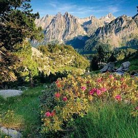
AIGÜESTORTES
Aigüestortes i Estany de Sant Maurici National Park is one of the 14 national parks in Spain, and the only one you can visit in Catalonia. It is one of the Quaternary glaciers that repeatedly covered Europe. Its presence is evident on the peaks, creating cirques, hanging valleys, and lakes—one of the park's most distinctive features. It is located in the northwestern corner of Catalonia, in the province of Lleida, in the heart of the Pyrenees mountain range.
It encompasses parts of the Alta Ribagorça, Pallars Sobirà, Val d'Aran, and Pallars Jussà regions. Here, water can be found in various forms: lakes, rivers, waterfalls, and more. In 2018, it was visited by half a million people, and its allure is such that it's practically a must-see.
We'll show you a route that's suitable for a large crowd and very spectacular.
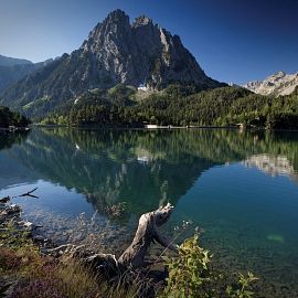
Estany de Sant Maurici and Els Encantats
This is the most famous lake in Aigüestortes (in fact, it gives it its name) and one of the most easily accessible. Taxis drop off and pick up people at the information booth next to the lake. The surrounding area can be explored even in a wheelchair via an 80-meter walkway. From this lake, over 1,000 meters long, our route begins towards the "Agulles d'Amitges," a 1-hour 45-minute walk away. Those who want to explore the area without overexerting themselves will find several intermediate stops that may suffice as an introduction to the park. Aside from the lake, the main attraction in this area are the two peaks called "Els Encantats," over 2,700 meters high. The best views of these two peaks and the gap that separates them, however, are from other points along the route. In the second photo, you can see the Estany de Ratera and, in the background, Els Encantats.
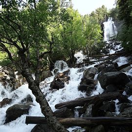
Ratera Waterfall
Thirty minutes from Estany de Sant Maurici is the beautiful Ratera Waterfall, which winds its way down the mountain with a drop of about 100 meters. From this area, you already have a good view of the lake and "Els Encantats," so for those less demanding or those who can't afford to go further for other reasons, this can be the end of a short hike. The path to it and the connections to other trails are well signposted throughout, as is typical throughout the park.
Ratera Lake
The route continues along the beautiful Estany de la Ratera, which is reached after a relatively easy climb of about 20/30 minutes from the waterfall. Once past the lake, those who aren't feeling fit have two options: return along the same path or turn off onto a trail on the left toward the Mirador de l'Estany de Sant Maurici, located 1 km from the lake. If it had been up to me, I would probably have opted for one of those two options, but my expedition companions were more enthusiastic, so we continued ascending along a "moderate" section toward the next checkpoint. Before starting the climb, be sure to look closely at the mountain, as this is an area where you might encounter marmots. We saw one scurrying in the distance... I think.
Amitges Refuge
After a tiring climb of about 45 minutes, you reach the Refugi d'Amitges, located at 2,380 meters above sea level. You can recharge your batteries at the bar-restaurant, although don't expect reasonable prices (which is understandable, by the way). If you're planning a longer hike, you can spend the night there for about €17. For amateur hikers like us, reaching the refuge seems like a feat comparable to climbing Mount Everest, so it's a little frustrating to see that some people take 4x4 taxis up there. Either way, the views over the valley are worth the effort.
Estany d'Amitges and Agulles d'Amitges
A few steps from the refuge is the Estany d'Amitges, the end point of the "Cap a les Agulles d'Amitges" itinerary. The name of this route comes from the two spires (agulles in Catalan) that jut out from behind the lake. The so-called "Agulla Gran d'Amitges" rises to 2,662 m. After enjoying the panoramic view, you can continue to two other nearby lakes, the Estany de la Munyidera and the Estany dels Barbs, either along the central path or skirting the Estany d'Amitges among the rocks. After thoroughly exploring the area, the question of returning arose. My companions, once again, decided to extend the route, so instead of retracing their steps, we returned to the climb to the refuge, where we connected with a 1-km trail that led to the Estany de les Obagues de Ratera.
Estany de les Obagues de Ratera
Although it's not part of the "official" itinerary, I admit it was a good idea to hike there, as it's perhaps the most photogenic lake in the area, and the trail allows you to enjoy it from a distance as you descend toward it. We took advantage of one of the streams that feeds it to dip our feet and eat. It's worth remembering, by the way, that swimming is prohibited throughout the park. And, obviously, don't leave any kind of waste or other traces of your visit there.
Mirador de l'Estany
Our trail continued for another 800 m on a comfortable descent along the river to the Mirador de l'Estany (the one we had discarded on the way up). From this point, there are, of course, unbeatable views of the Estany de Sant Maurici and Els Encantats. The return to the starting point can be done by retracing the route to the Estany de Ratera or by joining the "El Mirador de l'Estany de Sant Maurici" route, which involves circling the lake. Of course, my companions once again chose the longer route, so we continued through the Pico del Portarró ravine to finally find the path back to the Estany de Sant Maurici. This last stretch (perhaps due to fatigue) didn't seem the most spectacular to me, but it was the best way to round off a great route through Aigüestortes.
TECHNICAL SHEET AND ADDITIONAL INFORMATION
• Route: «Towards the Agulles d'Amitges» + «The Mirador de l'Estany de Sant Maurici»
• Type: on foot, circular route.
• Total distance: 12.32km (circular, joining the 2 routes)
Route only "Towards the Agulles d'Amitges": 9.16 km (round trip)
“El mirador de l'Estany de Sant Maurici” route only: 8.8km (circular)
• Total duration: 5h 15′ (+ breaks)
• Difficulty: moderate (Areas with fairly steep climbs from Estany de Ratera to Refugio d'Amitges. Several very stony areas along the route)
• Minimum/maximum altitude: 1909 m - 2377 m
• Elevation: 459 m.
• Recommended season: June - October
• Starting point: The ideal starting point is from Estany de Sant Maurici, where there is a 4×4 taxi stand. If you leave your car in the Prat de Pierró parking lot and decide to start walking from there, add about 50 minutes each way.
Estany de Sant Maurici and Els Encantats
This is the most famous lake in Aigüestortes (in fact, it gives it its name) and one of the most easily accessible. Taxis drop off and pick up people at the information booth next to the lake. The surrounding area can be explored even in a wheelchair via an 80-meter walkway. From this lake, over 1,000 meters long, our route begins towards the "Agulles d'Amitges," a 1-hour 45-minute walk away. Those who want to explore the area without overexerting themselves will find several intermediate stops that may suffice as an introduction to the park. Aside from the lake, the main attraction in this area are the two peaks called "Els Encantats," over 2,700 meters high. The best views of these two peaks and the gap that separates them, however, are from other points along the route. In the second photo, you can see the Estany de Ratera and, in the background, Els Encantats.
Ratera Waterfall
Thirty minutes from Estany de Sant Maurici is the beautiful Ratera Waterfall, which winds its way down the mountain with a drop of about 100 meters. From this area, you already have a good view of the lake and "Els Encantats," so for those less demanding or those who can't afford to go further for other reasons, this can be the end of a short hike. The path to it and the connections to other trails are well signposted throughout, as is typical throughout the park.
Ratera Lake
The route continues along the beautiful Estany de la Ratera, which is reached after a relatively easy climb of about 20/30 minutes from the waterfall. Once past the lake, those who aren't feeling fit have two options: return along the same path or turn off onto a trail on the left toward the Mirador de l'Estany de Sant Maurici, located 1 km from the lake. If it had been up to me, I would probably have opted for one of those two options, but my expedition companions were more enthusiastic, so we continued ascending along a "moderate" section toward the next checkpoint. Before starting the climb, be sure to look closely at the mountain, as this is an area where you might encounter marmots. We saw one scurrying in the distance... I think.
Amitges Refuge
After a tiring climb of about 45 minutes, you reach the Refugi d'Amitges, located at 2,380 meters above sea level. You can recharge your batteries at the bar-restaurant, although don't expect reasonable prices (which is understandable, by the way). If you're planning a longer hike, you can spend the night there for about €17. For amateur hikers like us, reaching the refuge seems like a feat comparable to climbing Mount Everest, so it's a little frustrating to see that some people take 4x4 taxis up there. Either way, the views over the valley are worth the effort.
Estany d'Amitges and Agulles d'Amitges
A few steps from the refuge is the Estany d'Amitges, the end point of the "Cap a les Agulles d'Amitges" itinerary. The name of this route comes from the two spires (agulles in Catalan) that jut out from behind the lake. The so-called "Agulla Gran d'Amitges" rises to 2,662 m. After enjoying the panoramic view, you can continue to two other nearby lakes, the Estany de la Munyidera and the Estany dels Barbs, either along the central path or skirting the Estany d'Amitges among the rocks. After thoroughly exploring the area, the question of returning arose. My companions, once again, decided to extend the route, so instead of retracing their steps, we returned to the climb to the refuge, where we connected with a 1-km trail that led to the Estany de les Obagues de Ratera.
Estany de les Obagues de Ratera
Although it's not part of the "official" itinerary, I admit it was a good idea to hike there, as it's perhaps the most photogenic lake in the area, and the trail allows you to enjoy it from a distance as you descend toward it. We took advantage of one of the streams that feeds it to dip our feet and eat. It's worth remembering, by the way, that swimming is prohibited throughout the park. And, obviously, don't leave any kind of waste or other traces of your visit there.
Mirador de l'Estany
Our trail continued for another 800 m on a comfortable descent along the river to the Mirador de l'Estany (the one we had discarded on the way up). From this point, there are, of course, unbeatable views of the Estany de Sant Maurici and Els Encantats. The return to the starting point can be done by retracing the route to the Estany de Ratera or by joining the "El Mirador de l'Estany de Sant Maurici" route, which involves circling the lake. Of course, my companions once again chose the longer route, so we continued through the Pico del Portarró ravine to finally find the path back to the Estany de Sant Maurici. This last stretch (perhaps due to fatigue) didn't seem the most spectacular to me, but it was the best way to round off a great route through Aigüestortes.
TECHNICAL SHEET AND ADDITIONAL INFORMATION
• Route: «Towards the Agulles d'Amitges» + «The Mirador de l'Estany de Sant Maurici»
• Type: on foot, circular route.
• Total distance: 12.32km (circular, joining the 2 routes)
Route only "Towards the Agulles d'Amitges": 9.16 km (round trip)
“El mirador de l'Estany de Sant Maurici” route only: 8.8km (circular)
• Total duration: 5h 15′ (+ breaks)
• Difficulty: moderate (Areas with fairly steep climbs from Estany de Ratera to Refugio d'Amitges. Several very stony areas along the route)
• Minimum/maximum altitude: 1909 m - 2377 m
• Elevation: 459 m.
• Recommended season: June - October
• Starting point: The ideal starting point is from Estany de Sant Maurici, where there is a 4×4 taxi stand. If you leave your car in the Prat de Pierró parking lot and decide to start walking from there, add about 50 minutes each way.